Tocht Mountainbike Mont Lozère et Goulet - GTMC2_J1 - Photo
 PhilippeC54
PhilippeC54

Gebruiker

© OpenStreetMap contributors
Lengte
Lengte
66 km
Max. hoogte
Max. hoogte
1560 m
Positief hoogteverschil
1210 m
Km-Effort
Km-Effort  
84 km
Min. hoogte
Min. hoogte
537 m
Negatief hoogteverschil
1834 m
Boucle
Boucle
Neen
Datum van aanmaak :
2016-06-14 00:00:00.0
Laatste wijziging :
2016-06-14 00:00:00.0

(0 Bericht)

Mountainbike
Mountainbike
5h15
Moeilijkheid : Moeilijk

Scan deze QR-code om de tocht te openen in de SityTrail-applicatie

Gratisgps-wandelapplicatie

Logo SityTrail SityTrail

IGN / Geografische instituten

SityTrail uit de App Store downloaden SityTrail uit Google Play downloaden

Logo SityTrail SityTrail World

De wereld gaat voor u open

SityTrail uit de App Store downloaden SityTrail uit Google Play downloaden SityTrail op Huawei AppGallery downloaden

Over ons

Tocht Mountainbike van 66 km beschikbaar op Occitanië, Lozère, Mont Lozère et Goulet. Deze tocht wordt voorgesteld door PhilippeC54.

Beschrijving

Auriac
Florac

Hoogteprofiel

Plaatsbepaling

Land:
France
Regio :
Occitanië
Departement/Provincie :
Lozère
Gemeente :
Mont Lozère et Goulet
Locatie:
Saint-Julien-du-Tournel
Vertrek:(Dec)
Vertrek:(UTM)
551661 ; 4926232 (31T) N.

Wandeltochten in de omgeving

Tocht Andere activiteiten Mont Lozère et Goulet - lundi - Photo
Andere activiteiten
olivier78000

Andere activiteiten

Medium
(1)
Mont Lozère et Goulet, Occitanië, Lozère, France
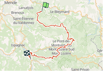
10,3 km | 14,5 km-effort
3h 29min
Neen
Tocht Stappen Mont Lozère et Goulet - Château de Tournel - Photo
Stappen
nolsim

Stappen

Medium
Mont Lozère et Goulet, Occitanië, Lozère, France
14,1 km | 22 km-effort
7h 25min
Ja
Tocht Stappen Mont Lozère et Goulet - Clochers de tourmente  - Photo
Stappen
pb07

Stappen

Medium
(2)
Mont Lozère et Goulet, Occitanië, Lozère, France
19,2 km | 27 km-effort
6h 8min
Ja
Tocht Stappen Mont Lozère et Goulet - Tournel Oulmes - Photo
Stappen
gege30

Stappen

Gemakkelijk
Mont Lozère et Goulet, Occitanië, Lozère, France
6,5 km | 9,4 km-effort
2h 40min
Ja
Tocht Paard Mont Lozère et Goulet - Auriac - Nissoulorgues - Photo
Paard
alfreson

Paard

Moeilijk
Mont Lozère et Goulet, Occitanië, Lozère, France
30 km | 39 km-effort
5h 11min
Neen
Tocht Paard Mont Lozère et Goulet - Auriac - Nissoulorgues - Photo
Paard
alfreson

Paard

Moeilijk
Mont Lozère et Goulet, Occitanië, Lozère, France
30 km | 39 km-effort
5h 11min
Neen
Tocht Stappen Lanuéjols - mont lozere - Photo
Stappen
olivier78000

Stappen

Gemakkelijk
Lanuéjols, Occitanië, Lozère, France
14,4 km | 19,9 km-effort
4h 2min
Neen
Tocht Stappen Chadenet - La Loubière - Lanuéjols  - Photo
Stappen
nolsim

Stappen

Medium
Chadenet, Occitanië, Lozère, France
17,7 km | 24 km-effort
4h 26min
Ja
Tocht Stappen Mont Lozère et Goulet - bagnols les bains Oultet St julien - Photo
Stappen
Matamimi

Stappen

Medium
Mont Lozère et Goulet, Occitanië, Lozère, France
13 km | 18,8 km-effort
5h 9min
Ja


Sluiten
Mijn abonnementen